Abstract
Location selection is one of the basic activities that require a thorough decision-making procedure for construction, expansion, or relocation of a specific project such as hospital, school, industrial zone, building, landfill, and residential sub-division. The main objective of this study is to select suitable sites for a small conference center with motel-style rooms in Thanh Hoa city. We applied GIS-based Multi-Criteria Decision Analysis (MCDA) and developed three models comprising the restriction model, the suitability model, and the integrated suitable locations model to observe the optimal location for a small conference center. Besides, the decision was based on the MCDA, Boolean/fuzzy overlay, and Weighted Linear Combinations (WLC). The integrated model showed the final suitable location for the construction of a small conference center with motel-style rooms indicated that 45 %, 14.6 %, 22.4 %, 17.5 %, and 0.5 % of the areas were unsuitable, least suitable, suitable, moderately suitable, and highly suitable respectively.
I. INTRODUCTION
Location selection is one of the key principles of construction planning that has a huge impact on the design of a proposed construction [1] and the success or failure of a project [2]. The selection procedure is the long-term investigation and complex decision due to multi-criteria and objectives, which rely on environmental, sociocultural, economic factors, and the distance to road and water resources, without conflict other purposes. Thus, construction is proposed for various aims that have different requirements and considerations for site selection. For example, a site suitable for residential buildings should be without agriculture or protection inside, or public health should considered in case of landfill construction.
The traditional approach to site selection is based on an analysis in terms of simple calculations, experience, or even preference. Decision procedure requires efforts from several experts from various fields to select the best alternative by considering the available information and geographical and spatial features [3]. In recent years, decision-makers have been applying geographic information systems (GIS) to support them in deciding due to the large influence of GIS in spatial analysis. GIS is used in conjunction with other methods such as decision support system (DSS) and multi-criteria decision analysis (MCDA). GIS-MCDA is a procedure that converts and integrates criteria or factors (geographic data) and decision-maker’s preferences to reach a final value judgment of the decision alternatives [3, 4]. GIS-MCDA remains a robust method that fine-tunes as well as uses non-spatial and spatial data to generate helpful information to make the best decisions [5]. As spatial decision issues, in general, it requires a comprehensive set of realistic multiple alternatives, conflicting goals, and evaluation criteria, thus the GIS-MCDA was proposed to decrease insecurities and give decision-makers the ability to make reliable judgments [6]; reduce the conflicts between stakeholders and decision-makers by providing a sound and acceptable assessment based on a logical, transparent, and documented procedure. Several studies applied GIS-based MCDA for location selection such as airport [7], wind farm [8], industrial zone [6], landfill [5, 9, 10], or incineration plant for municipal solid waste [11, 12].
The study aims to carry out land-use suitability with the view to identify the best location for a small conference center with motel-style rooms on the property at Thanh Hoa city, Vietnam that satisfies the following requirements 1) Construction should not impede the operation of the farm 2) Construction should not decrease the aesthetic and conservation value of the property. 3) Construction should not decrease the current income from farming and forestry, and 4) Construction is not exposed to significant flood hazards. In this study, the decision was based on the MCDA, Boolean overlay, and Weighted Linear Combinations (WLC).
II. METHODOLOGY
- Area study
Thanh Hoa city is located in the east of Thanh Hoa province, is in the center of Thanh Hoa Delta, which is the largest of the Central Coastal Plains. The city has an area of 147 km2 with many scattered rocky mountains, wide – narrow and shallow – deep fields surrounded. Besides, the city has a rivers system including Tho Hac, Coc, Lai Thanh, Nha Le, and Kenh Bac rivers, which supply irrigation, drought, and flood control, and water services for people in the city. In this area, a large portion of the annual precipitation (40–50% on average) occurs during the rainy season [13], with an average yearly temperature between 23.30C and 23.60C. The agriculture sector in Thanh Hoa city is dominated by paddy rice and orchard.
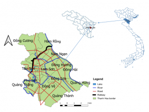
Figure 1: Map of Thanh Hoa city
- Summary of the Framework
Figure 2 summarizes the complete work-flow of the location selection for the small conference center in Thanh Hoa city.
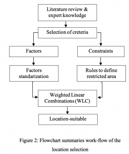
Figure 2: Flowchart summaries work-flow of the location selection
- Data preprocessing
The criteria that determine the location of a small conference center with motel-style rooms can be classified into the following groups: environmental and spatial criteria. The environment criteria include nature protection aspects, i.e. sensitive land such as protected area and surface waters, whereas the spatial criteria comprise slope and land use functions (rice paddy, other crops, and orchards). These criteria may be divided into factors and constraints. Factors that increase or decrease suitability are assessed on a fuzzy value include slope derived from Digital Elevation Model (DEM), distance to road, distance to water resources and, annual flood. Constraints determine the qualification of a given element and are usually of Boolean value expressed as 1 – suitable, and 0 – restricted. For example, the existence of a built-up area is restricted in the location of agriculture, forest, and flooding area.
Table 1: Individual criteria in Weighted Linear Combinations (WLC) analysis
| Data | Origin Type | Factors/ constraints | Setting
|
| Land 1: Protected-area | Raster | constraints | Inside the area =0, outside =1; (0= forbiddance; 1=allowance) |
| Land 2: Agriculture/Crops | Raster | constraints | Inside the area =0, outside =1; (0= forbiddance; 1=allowance) |
| Flood | Raster | constraints | scale of 1 to 10 from least to most suitable |
| Road networks | Vector | Factors | scale of 1 to 10 from least to most suitable |
| Hydrologic drainage systems | Vector | Factors | scale of 1 to 10 from least to most suitable |
| Slope | Raster | Factors | scale of 1 to 10 |
Vector datasets representing individual criteria were listed in Table 1 have been rasterized for the Weighted Linear Combinations (WLC) analysis. We generated:
- New classes from hydrologic drainage systems representing distance water sources included multiple buffer zones: 0 –200 m, 201– 350 m, 351–500 m, 500–650 m, 651– 800 m, and > 800 m. The class representing the distance sites (> 800 m) has been judged as the most suitable and as closest sites as the least suitable.
- New classes from road networks representing the distance to the road included multiple buffer zones 0–50 m, 51–250 m, 251–500 m, 501–750 m, 751–1000 m, and >1000 m. In these cases, the first buffer zone represented unsuitable areas for location. The class representing the distance areas (51–250 m) has been judged as the most suitable whereas distance ranged 0-50m and >1000 as the least suitable.
- The slope from DEM reclassified into five classes 0°–2.5°, 2.5°–5°, 5°–7.5°, 7.5°–10° and above 10°. The class representing flat areas (0° to 20). The class representing flat areas (0° to 2.5°) has been judged as the most suitable and the steepest areas as the least suitable.
Next, the assignment of weights is to rank the criteria in the order of the decision-makers preference [14]. Each factor was standardized on a scale of 1 to 10. In details, value of 1 was assigned to the least suitable whereas a value of 10 was assigned to the most suitable ones. Concerning constraint criteria, we set a value of 0 for forbiddance and 1 for allowance location (Table 1).
- Data preprocessing
The single factor raster maps were combined with different weight to represent their relative importance according to the formula 1. Figure 3 summarizes the complete work-flow of the combination. In this study, the authors has suggested the same weight among single factor, in other words, the index models have the same importance.
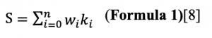
Where: S is the pixel score of the final location suitability, wi is weight of a factor i = 1, …, n k – value of factor i = 1, … n with n is number of factor.
In cases, where Boolean constraints also apply (i.e. protected areas, agriculture area), suitability score can be modified by multiplying the suitability calculated from the factors by the product of the constraints (Formula 2).
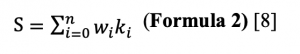
Where: cj is the score of the constraint j.
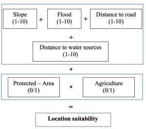
Figure 3: Multi- Objective Land Allocation
The categories assigned to the resulting accumulated values were: Most suitable, moderately suitable, suitable, least suitable, and not suitable. The description of such categories can be seen in Table 1. The locations with very high suitability for the construction include the longest distance to water sources, medium distance to the road (51–250 m, noise avoidance from transportation), lowest slope among others, and outside of agricultural and protected areas. In contrast, the sites with the least suitability are those with the longest distance to road, closest to water sources (erosion avoidance), highest slope. Finally, inconsonant sites (not suitable) are inside of agricultural and protected areas.
Table 2: Definition of site-suitability levels for conference center
| Location suitable level | Value | Description |
| Most suitable | 5 | Areas without significant limitations for the sustained construction of conference center. |
| Moderate suitable | 4 | Areas with no significant limitations for the sustained construction of conference center. They may have minor limitations without effects to the benefits. |
| Suitable | 3 | Areas of land with limitations that are altogether acceptable for the construction of conference center; these limitations will reduce advantages that can be gained from the construction, however, they are still attractive, will be significantly lower than expected in the areas with high/moderately suitability. |
| Least suitable | 2 | Areas with limitations that are collectively bad for the sustained construction of conference center. These limitations will reduce the benefits of construction significantly. |
| Not suitable | 1 | Construction is restricted |
III. RESULTS AND DISCUSSION
3.1. Single factor raster map
Single factor raster maps for the WLC analysis have been presented in Figure 3. The weight for each classification of particular criteria have been presented in table 1.
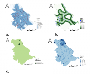
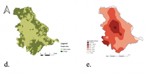
Figure 4: Single factor raster maps for the WLC analysis with a) Distance ranges to roads b) Distance ranges to water sources c) Protected area d) Crops area, and e) Ranges of slope
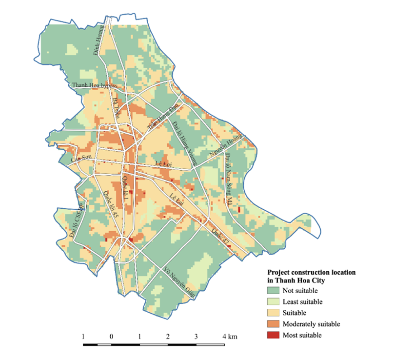
As the result of the WLC analysis, the most suitable sites have been identified and presented on a suitability map (Fig. 4). It shows areas that have pixel values equal to 5 (most suitable) and 4 (moderately suitable). The total area regarded as the most suitable with respect to the analyzed criteria is 401,300 square meters. However, these areas are scattered around the city with the area smaller than 2.000m2 for each whereas the area required for a conference center with motel-style rooms is approximately 2000 – 4000 m2. Therefore, the moderate suitable is the best option in our case. The largest and most uniform areas are located in the center part of the city. It should be mentioned that the locations identified are temporary and require further and more detailed investigation including field reconnaissance before the final decision is made.
In this location, the necessary facilities such as road, electricity, and water are already there, therefore the owner could avoid some cost on construction. Moreover, the center conference is constructed close to Thanh Lake, a good view which would be more attractive for people come for the conference. Furthermore, conservation mission is also achieved if this option is accepted. The areas were located the history site namely Ham Rong would be protected.

Figure 5: Results of land suitability analysis for a small c location
Many of the advantages of decision-making assisted with MCDA methods and GIS have been reported previously [15, 16]. However, as we mentioned in the above methodology that the weight among single factors/ constraints was skipped, in other words, the index models have the same importance. Therefore, finding is the uncertainty associated with allocating weights to the criteria due to the strong influence.
IV. CONCLUSIONS
This study presents an approach based on MCDM and GIS to identify suitable sites for a small conference in Thanh Hoa city, Vietnam. The MCDA included topographical, environmental, and land-use criteria based on expert knowledge, as well as data available from the study region. The final location-suitability maps showed that the center part of the study area has the highest suitability for a small conference center. Future research will focus on further exploration of appropriate multi-criteria decision methodology with consideration of the allocating weights to the criteria that would allow decision-makers to make such important decisions better and more efficiently.
REFERENCE
[1] . Cheng, E.W., H. Li, and L. Yu, A GIS approach to shopping mall location selection. Building and Environment, 2007. 42(2): p. 884-892.
[2] . Ghobarah, A., Civil engineers’ role in site-selection studies. Journal of professional issues in engineering, 1987. 113(4): p. 351-359.
[3] . Duarte, L., et al., Radio astronomy demonstrator: Assessment of the appropriate sites through a GIS open source application. ISPRS International Journal of Geo-Information, 2016. 5(11): p. 209.
[4] . Malczewski, J., GIS‐based multicriteria decision analysis: a survey of the literature. International journal of geographical information science, 2006. 20(7): p. 703-726.
[5] . Gbanie, S.P., et al., Modelling landfill location using geographic information systems (GIS) and multi-criteria decision analysis (MCDA): case study Bo, Southern Sierra Leone. Applied Geography, 2013. 36: p. 3-12.
[6] . Rikalovic, A., I. Cosic, and D. Lazarevic, GIS based multi-criteria analysis for industrial site selection. Procedia engineering, 2014. 69: p. 1054-1063.
[7] . Erkan, T.E. and W.M. Elsharida, Combining AHP and ROC with GIS for Airport Site Selection: A Case Study in Libya.ISPRS International Journal of Geo-Information, 2020. 9(5): p. 312.
[8] . Szurek, M., J. Blachowski, and A. Nowacka, GIS-based method for wind farm location multi-criteria analysis. Mining Science, 2014. 21.
[9] . ABESI, A. and M. SAEIDI, Site selection of a hazardous waste landfill using GIS technique and priority processing, a power plant waste in Qazvin Province case example. 2009.
[10] . Babalola, M.A., Application of GIS-Based Multi-Criteria Decision technique in exploration of suitable site options for anaerobic digestion of food and biodegradable waste in Oita City, Japan. Environments, 2018. 5(7): p. 77.
[11] . Korucu, M.K. and B. Erdagi, A criticism of applications with multi-criteria decision analysis that are used for the site selection for the disposal of municipal solid wastes. Waste Management, 2012. 32(12): p. 2315-2323.
[12] . Tavares, G., Z. Zsigraiová, and V. Semiao, Multi-criteria GIS-based siting of an incineration plant for municipal solid waste. Waste management, 2011. 31(9-10): p. 1960-1972.
[13] . press;, H.T.I. General Statistics Office of Vietnam. Statistical yearbook 2019; .
[14] . Malczewski, J., GIS-based land-use suitability analysis: a critical overview. Progress in planning, 2004. 62(1): p. 3-65.
[15] . Ozdemir, S. and G. Sahin, Multi-criteria decision-making in the location selection for a solar PV power plant using AHP.Measurement, 2018. 129: p. 218-226.
[16] . Tahri, M., M. Hakdaoui, and M. Maanan, The evaluation of solar farm locations applying Geographic Information System and Multi-Criteria Decision-Making methods: Case study in southern Morocco. Renewable and Sustainable Energy Reviews, 2015. 51: p. 1354-1362.